


Bel Com chez

Nono55
User
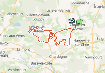

Length
46 km

Max alt
251 m

Uphill gradient
582 m
Km-Effort
54 km

Min alt
176 m

Downhill gradient
582 m
Boucle
Yes
Creation date :
2022-05-15 06:48:32.0
Updated on :
2022-05-15 19:28:58.604
3h25
Difficulty : Unknown

FREE GPS app for hiking
 SityTrail
IGN / Geographical institutes
SityTrail Plus
The world is yours!
About
Trail Mountain bike of 46 km to be discovered at Grand Est, Meuse, Les Hauts-de-Chée. This trail is proposed by Nono55.
Description
Sortie organisation au top
Single track a foison
Pas dur
Temps au top
Positioning
Country:
France
Region :
Grand Est
Department/Province :
Meuse
Municipality :
Les Hauts-de-Chée
Location:
Unknown
Start:(Dec)
Start:(UTM)
658904 ; 5415042 (31U) N.
Comments